http://tmml.sourceforge.net/doc/tcllib/mapproj.html
The 'mapproj' package in tcllib contains the conversions between geodetic (See geodesy) and map co-ordinates for a variety of map projections. A large number of projections are supported, because different applications have different needs.
Choosing a Projection
The mapproj manual gives a discussion of the choice of projections. Here is a review that attempts to illustrate some of the major points.
First: What sort of data are you displaying?
- Are directions the key point (winds, ocean currents, magnetic fields, navigational headings?) These are directional data; for directional data, you usually need a conformal projection.
- Are properties of the land or water the key point (temperature, population density, land use, demographics, etc.?) These are thematic data. For thematic data, you usually need an equal area projection.
- Is the significant aspect of your data that it shows distances from (or near to) a specific point? If so, you need an equidistant projection.
- Is the significant aspect of your data that it shows directions from (or near to) a specific point (for instance, radio antenna pointing, air routes, sight lines?) If so, you need an 'azimuthal' projection
- Do you have mixed data, or political data? You'll probably want a projection that is a compromise among the concerns above.
Second: What scale is your map?
- Is it global? All projections are going to be compromises. The Mercator projection is conformal, but grossly distorts land areas. Several attractive equal-area projections are available. In addition, the Robinson projection gives attractive political world maps, and the Peirce Quincuncial projection, while curious, distorts landforms very little.
- Is it a map of a hemisphere (or a large fraction thereof?) The stereographic, azimuthal-equidistant, Hammed and Mollweide projections all can project a hemisphere onto a circle.
- Is it a large area (a few hundred km on a side?) The most attractive choice of projection depends on where on the globe it is, and whether it has a predominantly east-west or north-south extent.
- Is it a small area? In order to have map scales correct, you need to lift co-ordinates from the reference ellipsoid onto a sphere. See geodesy for a more detailed discussion.
Examples of Projections
Projections Suitable for World Maps
These projections are suitable for world mapping, either because they are traditional or because they preserve particular aspects of the map especially well.
Cylindrical Equal Area
Cylindrical equal-area projections have the advantage that they preserve land areas. Equal-area projections are, of course, preferred to present data on land use, or to present demographics. They do not have the fault of the traditional Mercator projection of exaggerating the visual importance of the high latitudes.
For any cylindrical equal-area projection, there will be one latitude (or rather, a pair of equal latitudes, North and South) where landforms are preserved. Above the reference latitude, landforms will be stretched east to west. Below it, they will be stretched north to south.
Lambert
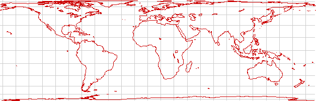
The Lambert projection is a cylindrical equal-area projection with a reference latitude of the Equator. It preserves equatorial landforms especially well but distorts the temperate and polar regions.


| Category Tcllib | Category Geography |
|---|